Oil & Gas Fields of the Former Soviet Union Database
The Former Soviet Union Oilfield Database is a geological database, containing information on the nature, age, depth, geological and petrophysical properties of the reservoirs. Now including data on petroleum sources and sealing horizons
Download a Free Demonstration Version (2.94MB)
Requires Microsoft Access 2000 or later
Data on production, reserves, economic indicators and other parameters are included for many fields. Details on separate accumulations within the fields are also included.
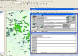
For clients using ArcGIS, our new ArcMap™ Oilfield mapallows instant access to the database from georeferenced fields.
Well data stored in an ODM3™ (Version 3.5 or later) database can be accessed directly from the field database via a link.
Based on data published in Russian and English, and supplemented by scout data from various sources, the information contained in the database is subject to constant review and updating, with coverage being increased all the time.
This database can be purchased either as individual databases on different hydrocarbon provinces or as a complete database encompassing the entire Former Soviet Union:
| Database | Includes |
|---|---|
| South Caspian Province 148 fields 517 accumulations |
Eastern Georgia Azerbaijan South Caspian Basin Western Turkmenistan |
| North Caucasus Province 373 fields 623 accumulations |
Black Sea to the Caspian Sea North to the Rostov oblast East to the Precaspian Basin |
| Precaspian Basin 188 fields 541 accumulations |
Russian sector Kazakhstan sector |
| Mangyhslak & Ustyurt 93 fields 292 accumulations |
Buzachi Arch North Ustyurt Trough South Mangyshlak Trough Uzen Step |
| Amu Dar'ya Basin 206 fields 403 accumulations |
Central & Eastern Turkmenistan Southwest Uzbekistan |
| West Siberian Basin 876 fields 1107 accumulations |
|
| Russian Far East 116 fields 400 accumulations |
Entire Russian Area to the East of the Verkhoyan Ridge |
| Complete Database 4314 fields 7873 accumulations |
All of above plus Rest of Kazakhstan Tajikistan Eastern Siberia Timan-Pechora Volga-Urals Baltic Black Sea |
For further details, including costs, please contact Dr Graham Blackbourn.

Oil & gas field database interface using ArcMap™
Hydrocarbon Province Maps
The database is illustrated with colour hydrocarbon province maps, showing the distribution of hydrocarbon fields and structural features of each region.
Individual fields are illustrated by structure contour maps, cross sections and representative well logs.
Files available to download and/or print:
